Published by Max Barel on 2026-04-20
Iphigénie X, the hiking map Overview
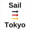
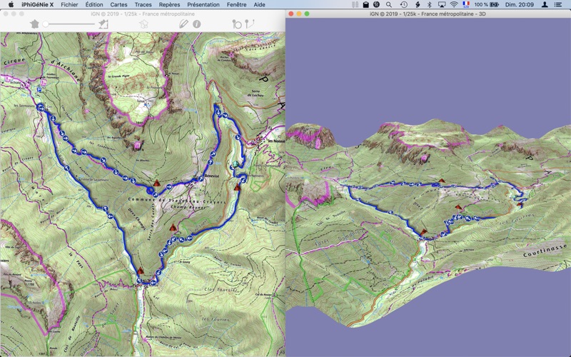
What is Iphigénie X, the hiking map? iPhiGéNie is a mapping application that provides access to French topographical maps from Institut Géographique National. It offers a 7-day free trial with full access to all features and maps. After the trial period, the application switches to restricted mode, where some features are locked down, and IGN topographic SCAN maps are no longer available. The app offers in-app purchases, including an annual subscription to the map services of the French IGN, which gives full access to reference topographic maps, and the Xmax module, which unlocks all advanced features. It also provides free worldwide coverage through OpenTopoMap/OpenCycleMap and free topographical maps from national mapping authorities of Switzerland, Spain, Catalonia, Norway, Italy, and Germany. The app offers features such as 3D display, offline maps, and search for addresses or toponyms present on a French map. It also allows communication with mobile devices connected on the local network to display and exchange data.
1. Available as a free download, this application offer a 7 days free trial, when all features are active and access to French maps is granted for all layers and scales.
2. • The annual subscription to the map services of the French IGN gives full access to reference topographic maps, SCAN25 et SCAN100, OACI.
3. One can use the application, with no time limitation, on those free maps sources.
4. It is possible to share the subscription to the Geoportail from the iOS version of iPhiGéNie, using a transfer token, while not exceeding the limit of 5 devices.
5. iPhiGéNie has all the features needed for working on your outdors tracks and projects, download tracks and markers you made on the field, printing and 3D.
6. All free maps sources remain available.
7. iPhiGéNie is the tool of choice for French topographical maps.
8. Free topographic Swiss maps with SwissTopo.
9. Gives access to topographic maps of BELGIUM.
10. Subscription to Cartoweb Begium maps.
11. • IGN topographics SCAN maps (SCAN25 et SCAN100, OACI) are no longer available.
Download and Install Iphigénie X, the hiking map - PC
Download for PC - server 1 --> Pcmacstore.com