Topo Maps+

Topo Maps+ for PC and Mac

Published by Glacier Peak Studios LLC on 2024-03-13

  • Compatibility: Available on Windows 11, Windows 10, Windows 7 & MacOS 10, 11, 10.12
  • Category: Travel
  • Licence: Free
  • Software version: 7.6.1
  • File size: 31.15 MB


Download ⇩


Topo Maps+ Overview

What is Topo Maps+? Topo Maps+ is an app designed for outdoor enthusiasts to plan and navigate their trips in the backcountry. The app offers planning tools such as map comparison, overlay customization, and route-building tools. It also provides trustworthy maps from various sources, including USGS, US Forest Service, Natural Atlas, and ESRI's ArcGIS. The app offers on-trail tools such as current location tracking, track recording, proximity alerts, and photo waypoints. The app also provides helpful tips and tricks for keeping users safe in the backcountry. The app offers both free and subscription-based access to high-resolution maps and advanced features. The app allows users to sync their data, subscriptions, and waypoints between all their iOS devices. The app's subscription will be charged to the user's Apple ID account and can be managed and canceled through the App Store account settings. The app's privacy policy and terms of service are available on the developer's website.


Screenshots

→   →   →   →   →  


Topo Maps+ Features and Description

1. From the Gold Standard of traditional USGS, the backcountry features of the US Forest Service, Satellite Imagery, Land Use, Land Cover, the incredible Natural Atlas, NOAA Marine Maps, Canada’s NRCAN/GEOBC, New Zealand Topo Maps from LINZ.

2. For high resolution maps there are both subscription access to premium maps & features as well as the ability to purchase individual maps from National Geographic, Benchmark, and Canada’s Backroad Mapbooks.

3. Designed and tested on real dirt by outdoor enthusiasts, Topo Maps+ is packed with good planning tools, trustworthy maps, on-trail tools, and tips to enhance YOUR navigational mindset.

4. Topo Maps+ subscriptions will be charged to your Microsoft ID account at the confirmation of purchase.

5. Annual or Quarterly Pro Subscription: Access to high resolutions maps, premium maps, and advanced features.

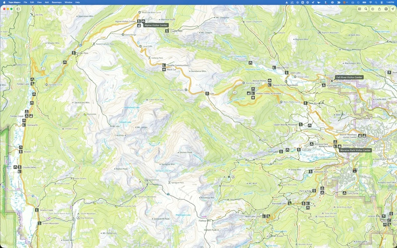
6. Topo Maps+ for Windows has the complete feature set to plan your trip and keep you safe in the backcountry.

7. Any unused portion of a free trial period, if offered, will be forfeited when the you purchase a subscription.

8. You can manage and cancel your subscriptions by going to your account settings on the App Store after purchase.

9. Your account will be charged for renewal within 24 hours prior to the end of the current period.

10. Subscription automatically renews unless it is canceled at least 24 hours before the end of the current period.

11. Purchases (subscription and individual maps) can be used across all your Microsoft devices.


Pros:

  • - Easy to use
  • - Great tech support
  • - Uses very little battery energy
  • - Easy to plan a route or just to check where your at
  • - Very accurate for trails
  • - Uses the path that others have hiked on when there are multiple paths/trails or old trails on maps
  • - Recent updates & availability of the USFS MVUM maps
  • - Activate the Natural Atlas map along with the USFS MVUM maps
  • - Paid the extra for the better Dif version, much improved, worth it
  • - Responsive and easy to use
  • - Array of data that can be configured in the map overlays
  • - Cross-refrence the trusty old USGS quads with newer USFS maps
  • - GPS traces of USFS trails and roads
  • - Route creation tools
  • - Hunt subscription for the new private and public land parcel overlays

Download Topo Maps+ Latest Version


Download and Install Topo Maps+ - PC

Download for PC - server 1 -->

PC Alternatives:
Get Alternatives for Windows

MAC Download:
Download for MacOS - server 1 --> Free

Installation Requirements

PC Compactibility/Requirements for Installation

Compactible OS list:
  1. Windows 11
  2. Windows 10
  3. Windows 8.1
  4. Windows 7
  5. Windows Vista

Requirements for MacOS Installation

Intel, 64-bit processor, OS X 10.7 or later.

Compactible OS list:
  1. macOS Ventura: 13.3
  2. macOS Monterey: 12.6.4
  3. macOS Big Sur: 11.7.5
  4. macOS Catalina: 10.15
  5. macOS Mojave: 10.14
  6. macOS High Sierra: 10.13

FAQs

Topo Maps+ - Is it safe to download?

Yes. The app is 100 percent (100%) safe to download and Install. Our download links are from safe sources and are frequently virus scanned to protect you

Software Reviews and Criticism


  • By Junk-jcp

    5 Stars This is the best Hiking App

    This is the best hiking app. Easy to use, great tech support, uses very little battery energy. Easy to plan a route or just to check where your at. Very accurate for trails, it uses the path that others have hiked on when there are multiple paths/trails or old trails on maps. I have used this for 2 years in Yellowstone and Grand Teton National Parks.


  • By Electro.Shock

    Perfect Overlanding Map

    Recent updates & availability of the USFS MVUM maps have made this my go to map. Activate the Natural Atlas map along with the USFS MVUM maps and together you have a map that no other application or website can touch. Awesome!


  • By curleyR

    Impressive!

    I paid the extra for the better Dif version, much improved, worth it! I would have given 5 stars, but it won’t work on my iPad……that’s a big negative….if you can’t tke it with you, then that’s a disadvantage. It’s my fault that I didn’t pay closer attention to what it was rated to work on. 5/11/19 C. UPDATE 5/13/19- Developer contacted me and explained how to use the app on iPad. Thanks! Now I’ll know where I am when I’m lost……. :)


  • By Caleb-G

    Hands-Down The Best Mapping App

    The app is responsive, and easy to use and makes a really wonderful planning companion for the excellent iOS app. The array of data that can be configured in the map overlays is the most valuble part, espically with a Pro or Hunt Subscription. I can easily cross-refrence the trusty old USGS quads with newer USFS maps, and the really excellent Natural Atlas. With just a few clicks I can overlay GPS traces of USFS trails and roads, and with the route creation tools, can chain a series of these trails together to create a route for multiple-day backpacking trips. I have the Hunt subscription for the new private and public land parcel overlays. These are very accurate, and help avoid trespassing in places where fencelines are either non-existant, or way off of the land boundaries. And, I don't need a seperate app and paid subscription to get this data! The Windows app UI does feel a little odd – I think this is because the Windows App is based on the iPad app. You are using a UI that is optimized for touch on a computer with precision input devices and a full keyboard. But this is a minor niggle, as the UI is better than any of the alternatives. I've been using this app and the iOS version for years now, and I don't expect that to change. It's great, and the subscriptions are well worth the cost if you do much map-related activities.


  • By Jamie_Pizzarello

    A Must-Have for All Hikers!

    I've been paid pro user of this app for over 2 years now and have used it on every single hike. Topomaps has worked without issue and has NEVER crashed on me. The interface is easy to use to plan and to navigate while on the trail, and It does a great job tracking my location. Their map overlays are great and provide so much detail. When I've had some questions or minor issues, their technical support has been unbelievably responsive! The several times I've contacted them they've replied within a day or so and have resolved any issue I had. I definitely recommend Topomaps


Leave a review or comment


keyboard_arrow_up