GPX Editor

GPX Editor for PC and Mac

Published by William Modesitt on 2024-04-16

  • Compatibility: Available on Windows 11, Windows 10, Windows 7 & MacOS 10, 11, 10.12
  • Category: Travel
  • Licence: $4.99
  • Software version: 3.12.07
  • File size: 5.51 MB


Download ⇩


GPX Editor Overview

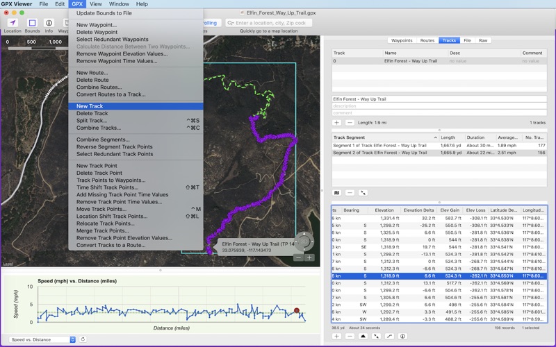
What is GPX Editor? GPX Editor is a Mac application that allows users to edit GPS eXchange format (GPX) files. It can open, edit, and save multiple GPX files, view them with Apple Maps, Google, or Open Street Maps, and edit waypoints, routes, tracks, track points, and file info. The app also allows users to view charts such as elevation vs. track point, copy and paste waypoints, routes, tracks, and file info, drag waypoints and track points to a new location on the map, add new waypoints, routes, tracks, and track points, and get current weather and elevation for any waypoint or track point. Additionally, users can take a screenshot of the map for printing or reference, export track points as a tab-delimited file, change pin, route, and track colors, search for photos and videos at any waypoint or track point location, delete waypoints, routes, and track points, merge track points, combine track segments, combine tracks, convert track points into waypoints, delete track segments, and more. The app ignores GPX extensions.


Screenshots

→   →   →   →   →  


GPX Editor Features and Description

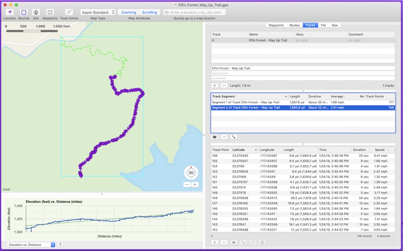
1. - View and edit waypoints, routes, tracks, track points, and file info.

2. - Delete waypoints, routes and track points to refine your GPX file.

3. - Add new waypoints, routes, tracks and track points.

4. - Drag and drop track points to rearrange their ordering (within the track point list).

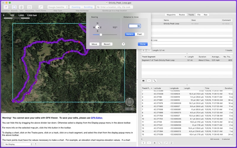
5. - Drag waypoints and track points to a new location on the map.

6. - Flickr search for photos and videos at any waypoint or track point location.

7. - Copy waypoints, routes, tracks and file info and paste to a spreadsheet.

8. - Export the track points as a tab-delimited file.

9. - Download elevation for any waypoint or track point.

10. track point (when elevation exists).

11. - Copy & paste waypoints, routes, and tracks from one file to another.


Pros:

  • - Easy to curate collections of lots of tracks
  • - Responsive to feature requests
  • - Allows users to merge and split tracks
  • - Allows users to tweak points by dragging them on the map
  • - Allows users to timeshift points
  • - Allows users to geo-tag photos

Download GPX Editor Latest Version


Download and Install GPX Editor - PC

Download for PC - server 1 -->

PC Alternatives:
Get Alternatives for Windows

MAC Download:
Download for MacOS - server 1 --> $4.99

Installation Requirements

PC Compactibility/Requirements for Installation

Compactible OS list:
  1. Windows 11
  2. Windows 10
  3. Windows 8.1
  4. Windows 7
  5. Windows Vista

Requirements for MacOS Installation

Intel, 64-bit processor, OS X 10.7 or later.

Compactible OS list:
  1. macOS Ventura: 13.3
  2. macOS Monterey: 12.6.4
  3. macOS Big Sur: 11.7.5
  4. macOS Catalina: 10.15
  5. macOS Mojave: 10.14
  6. macOS High Sierra: 10.13

FAQs

GPX Editor - Is it safe to download?

Yes. The app is 100 percent (100%) safe to download and Install. Our download links are from safe sources and are frequently virus scanned to protect you

Software Reviews and Criticism


  • By Glen's GPS

    Excellent Support & good replacement for VantagePoint

    I recently purchased GPX Editor to run on my PC. I have been moving data from VantagePoint (which doesn’t run on a Windows) into it. I wanted to add two waypoints which I did successfully and then I wanted to change the date and time field to reflect when I was at the two waypoints (I dive and mark my diving sites based on the time stamp in my dive computer) I couldn't seem to open the date and time field and make a change. I addressed this issue to the developer and received a very kind reply from William Modesitt telling me he would address the issue in a future update. Within 24 hours I looked for an update in the app store and there it was. With the new update, I was able to edit my new waypoints. I have worked in the IT field since 1981 and have NEVER had this kind of service from a developer. Thanks!


  • By iAneel

    A handy tool to have in your collection

    This app isn’t the end-all-be-all of GPS data editing, but it’s useful for the thing that it specializes in: editing GPX tracks. It’s the easiest interface I’ve found to curate collections of lots of tracks. I just got back from a trip where I had multiple GPS units running at the same time and needed to reconcile their data. I did the repetitive work with a Python script, and then cleaned up the results by hand using this tool. It made it easy to split and join tracks and to tweak points by dragging them on the map. The author is quite responsive to feature requests.


  • By aplnub

    Landscape Photographer - Excellent App

    I do a lot of hiking and photographing landscapes. I use my phone to track my hikes and then export a GPX file to geo-tag my photos to the locations at which they were photogaphed. I didn’t realize Adobe Lightroom had a 50,000 point max import. This app allowed me to merge every two points to cut my 75,340 points to half so I would be under the 50,000 point import. I was also able to timeshift the points with ease (all 75,340 points). I did contact the developer with a question and he responded same day. Don’t hesitate if you need a little help with GPX files.


  • By jimlapbap

    Very tedious to use, would be fantastic with some shortcuts

    This would be fantastic if there were some shortcuts around the very repetitive things. For example, when routing through waypoints, you have to double click each waypoint, and some of my gpx files have 10,000 waypoints (so I had to write an automating script to double click each one, and it STILL took an hour). If there were some way to just say "I want all these waypoints in order" that would save me hours. Also, there are certain preferences you cannot control. For example, if you add a waypoint, a pop up menu comes up, and if it's over the next waypoint, you might accidentally open the waypoint in a map. There is little to no official support, because I cannot find answers or workarounds to any questions anywhere online. The user manual is basic at best. I know it's a $5 app, but it's the only thing I can find for Windows that allows you to edit GPX files with a graphic user interface. Some tweaks to make it easier would easily bump this up to 5 stars, but for now, it's very frustrating spending hours shift-cliking and double clicking on a single file.


  • By scattergather

    Great software crippled by minor issues.

    I bought it so I can combine multiple GPS captures into a single clean track that I can share on mapping services. The biggest omission is that you can’t reverse a route, so you can’t combine traces from inbound and outbound trips. You can reverse the order of track points, but the app won’t change their timestamps, so whatever you do next will effectively put them back in their original order. You have to use online services to do the reverse, then manually mess around with time shifting to get the timestamps close so the combined route is contiguous in the correct direction. Other bugs: Operations like reverse track points or manual track point reorder do not update the map. You must save, exit, and reopen the app to see the effect. You can’t quit without saving changes. You must make manual duplicates of your file after every operation so you don’t lose work if the app does something you don’t expect and can’t undo. Undo delete point is broken. The restored point will go to the end of the track instead of where it used to be. Operations like Combine Segments/Tracks are not undoable at all. Selected and unselected track points look the same on the map. You must memorize point numbers and manually select from a list to select a set of points. No rectangle selection. Routes from a GPS tracker easily number thousands of points so this minor omission is a big PITA.


Leave a review or comment


keyboard_arrow_up